Dangerous heat wave in Maryland expected to continue through Wednesday
 By
,
By
,

A heat wave sent temperatures to near record levels in Baltimore Monday. BWI-Marshall fell just short of the record 98° set in 2024 while the Inner Harbor peaked at 104° Monday afternoon. Record or not, it was extremely warm across the state.
The dangerous temperatures are expected to continue through Wednesday in Maryland.
Residents are advised to take heat precautions seriously, as the temperatures will be dangerous even to healthy individuals.
Baltimore has declared a Code Red extreme heat alert through Thursday, June 26.
Howard County has declared a heat alert through Tuesday, June 24.
Extreme heat in Maryland
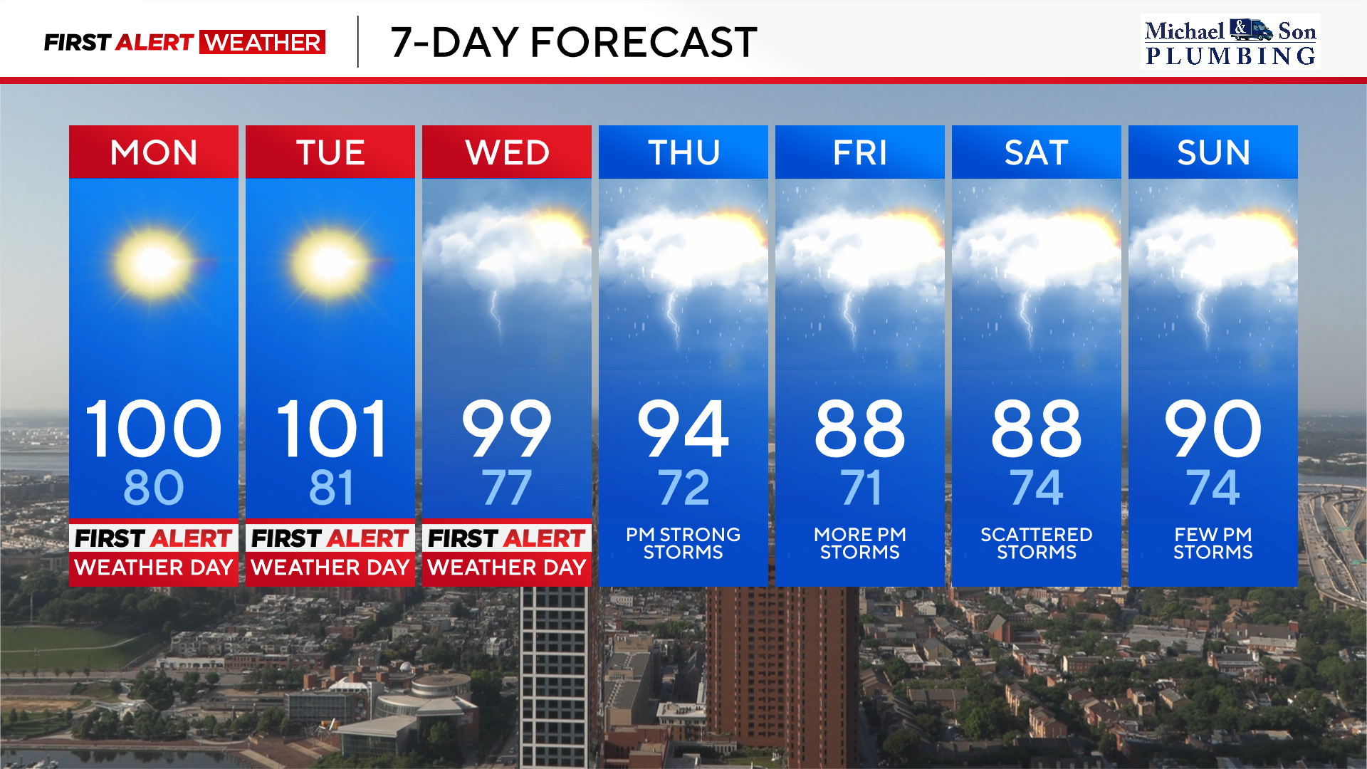
The combination of near triple-digit heat and elevated humidity levels has prompted the WJZ First Alert Weather team to issue Alert Days through Wednesday, June 25.
High temperatures are forecast to approach, if not reach, the lower 100s again on Tuesday. We'll once again be monitoring as that is near-record heat. Our normal high temperatures for late June are in the upper 80s.
We could also see low temperature records challenged the next couple of nights. Monday night will fall into the 70s and low 80s, the warmest low temperature for June 24th at BWI Airport is 76°, set in 2010. The record warmest low temperature for June 25th is 78°, set all the way back in 1875.
Wednesday will also feature dangerous heat, but high temperatures should fall just shy of 100°. BWI's record high is 99° from 1997.
Regardless of whether we see records fall the next couple of days, prepare for more highly uncomfortable levels of heat and humidity statewide.
Isolated strong thunderstorms are possible Wednesday afternoon, but a much better chance of storms returns Thursday. Feels like temperatures will be between 105° and as high as 115°.
Heat alerts in Maryland
Heat is the number one weather-related cause of death in the United States. Please take the Alert Days seriously, especially if you will be outdoors in the next couple of days.
As the extreme heat continues, additional heat alerts will be active across much of Maryland:
- The Eastern Shore is under an extreme heat warning through Wednesday at 8 p.m.
- Another extreme heat warning will go into place for central Maryland at 11 a.m. Tuesday through 9 p.m.. Feels like temperatures could approach 110° for these areas.
- An extreme heat watch will go into place for central Maryland at 11 a.m. Wednesday through 9 p.m.. Feels like temperatures could approach 110° for these areas
Regardless of whether or not your neighborhood is under an alert, the entire area will be extremely hot and humid, even overnight. Low temperatures in the 70s and 80s are warm enough, but with high levels of moisture, we'll wake up already feeling like the mid-80s.
Staying cool during Maryland heat wave
Here are a few ways to stay safe and healthy while working outside during extreme heat:
- Wear loose-fitting, light colored clothing
- Avoid being in the direct rays of the sun
- Take frequent breaks if you plan to be outdoors
- Drink lots of water, even if you don't feel thirsty. Two liters of water a day is recommended
- Remember pets and the elderly in the heat
- Make sure ceiling fans are circulating counterclockwise to circulate cooler air downward
In preparation for the unusually hot weather, Baltimore City's Health Department is declaring its first 'Code Red Extreme' Heat Alert. The alert begins Sunday and runs through the middle of the week.
Stormy weather mid-week
A cold front will sag south late this week into next weekend, bringing us some relief from the dangerous heat. Thursday's high temperatures will still reach the lower to middle 90s with tropical levels of humidity. This will allow the feels like temperature to reach 100°.
Scattered heavy to strong thunderstorms will be possible Thursday afternoon and evening, bringing some relief from the heat.
This same cold front will drape across our area Friday and Saturday. Additional clouds, showers and thunderstorms should allow temperatures to stay in the upper 80s to around 90° Friday and Saturday.
Humidity levels will be high, but the temperatures will not be as extreme.


