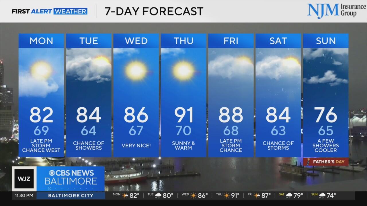
Quiet Monday expected across Maryland; storms possible at night

An upper level disturbance will bring a continued chance for showers and storms through a portion of tonight across the area. The overall threat for severe weather has diminished with the most likely area to see severe storms through midnight south of the Potomac across Virginia and perhaps a portion of southern Maryland.
Otherwise showers and storms with heavy downpours and occasional lightning can be expected through midnight.
After midnight, the severe threat should diminish as the atmosphere begins to stabilize. Overnight conditions will turn quieter with partly to mostly cloudy skies and lows remaining mild, generally in the mid to upper 60s.
Unsettled Start to the Week
Monday will start off dry for many, with a mix of sunshine and clouds through the morning hours. However, the break will be brief. Another round of storms is expected to develop by Monday night.The Storm Prediction Center has placed much of the region under a Marginal Risk for severe storms for late Monday, with the potential for damaging winds and locally heavy rain once again.
Temperatures on Monday will climb into the low to mid 80s. Again, most of the day will be dry for outdoor activities.
Cold Front Arrives Tuesday
A cold front will approach and move through the region on Tuesday. The best chance for showers and storms will come during the morning hours, especially east of I-95, as the front sweeps eastward. Behind the front, slightly drier and more comfortable air will begin to filter into the region, though temperatures will remain warm with highs in the low to mid 80s.
The passage of this front will mark the beginning of a brief stretch of quieter weather midweek.
Warm and Sunny Midweek Forecast
High pressure will build in from the west on Wednesday and Thursday, leading to a period of dry and mostly sunny weather. Afternoon highs will approach 90 degrees, especially on Thursday, with noticeably lower humidity and overnight lows dropping into the 60s.
This will likely be the most pleasant stretch of the week, offering a break from the repeated thunderstorm chances that have affected the region since the weekend.
Stormy Pattern Returns for Father's Day Weekend
By Friday, another cold front will begin to approach from the west. Increasing moisture and instability ahead of the front will lead to a renewed chance for scattered storms, especially Friday afternoon and evening.
Unlike earlier in the week, this front is expected to slow down or stall across the region, leading to prolonged rain chances that may persist through the weekend. As a result, both Saturday and Father's Day on Sunday could feature periods of showers and thunderstorms, with locally heavy rain possible at times.
Temperatures will trend cooler as clouds and rainfall become more persistent. Highs on Saturday and Sunday are expected to fall back into the mid to upper 70s, a noticeable change from the summerlike warmth earlier in the week.