Storms expected across Maryland again Tuesday

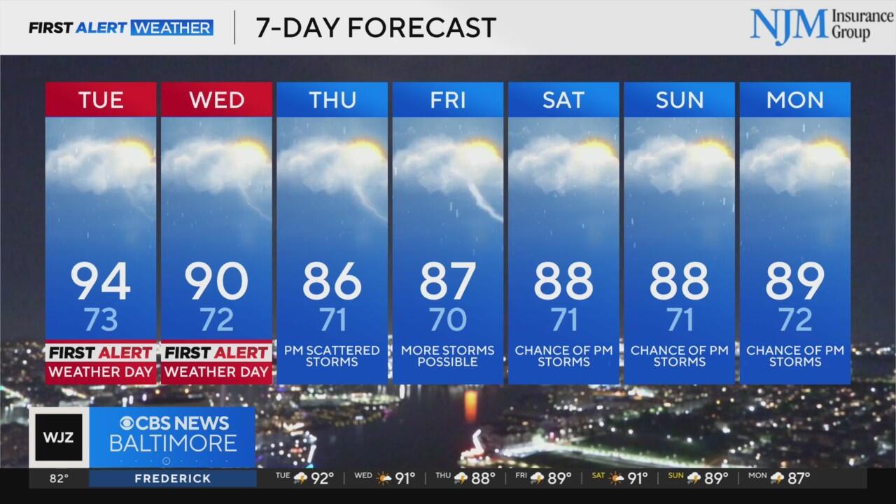
A stretch of hot, humid, and stormy weather is taking aim at the region this week, prompting WJZ to issue First Alert Weather Days for Tuesday and Wednesday due to the threat of severe thunderstorms.
Overnight Monday into early Tuesday will remain very warm and humid, with temperatures holding in the 70s and areas of patchy fog developing by morning.
By Tuesday afternoon, conditions will become more volatile as a surge of heat and humidity sets the stage for scattered thunderstorms, some of which may become severe. Damaging wind gusts, torrential rainfall, and frequent lightning are all possible, particularly after 2 p.m. through the early evening.
Before the storms arrive, expect highs in the low to mid 90s, with heat index values potentially exceeding 105 degrees, adding to the discomfort and increasing the risk of heat-related illness.
Storms will taper off Tuesday night, but patchy fog and warm overnight lows in the low to mid 70s will linger.
On Wednesday, another round of afternoon and evening storms is expected as a slow-moving cold front remains stalled across the region. Once again, severe weather is possible, with gusty winds, heavy rain, and frequent lightning. Flash flooding could become a concern, particularly in areas that receive repeated rounds of heavy rain.
That same front is forecast to linger through the end of the week and into the weekend, keeping the region locked in a pattern of daily thunderstorm chances, primarily during the afternoon and evening hours. While not every day will be a washout, outdoor plans should be made with flexibility in mind. Mornings and early afternoons should remain mostly dry, with highs in the upper 80s to near 90 and overnight lows in the 70s.
Residents are urged to stay weather aware over the next several days, especially during peak heating hours when severe storms are most likely to erupt.