Enhanced severe storm risk, extreme heat prompt NEXT Weather Alert for Twin Cities


Sunday is a NEXT Weather Alert day for two reasons: extreme heat and the potential for severe weather.
A flash flood warning for Ramsey County and central Washington County is in effect until Monday at 12:30 a.m., according to the National Weather Service. A similar warning for Stevens County is in effect until 10 p.m.
Roseville Police said about three vehicles were stranded due to flooding and had to be towed. The Roseville Fire Department escorted one person from a vehicle. No injuries were reported.
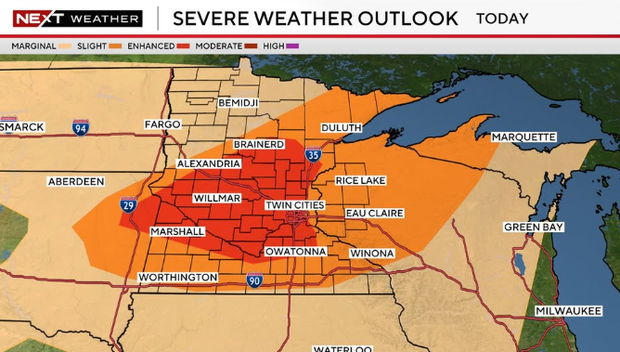
Parts of central and southern Minnesota, including the Twin Cities, have an enhanced risk (3 out of 5) for severe weather in the evening to overnight hours Sunday. The rest of Minnesota and western Wisconsin have either a slight (2 out of 5) or marginal (1 out of 5) risk for severe weather.
The biggest threats are damaging winds and hail. Tornadoes are also possible.
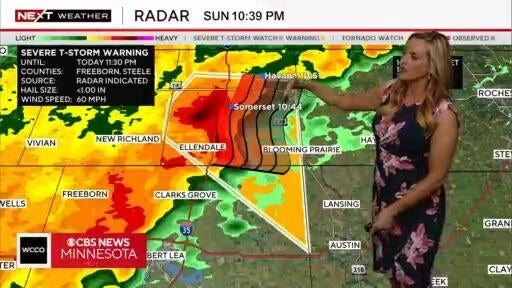
The National Weather Service confirmed a tornado touched down near Appleton in west-central Minnesota early Sunday afternoon. No injuries have been reported.
Anyone at home during a tornado should go to the basement or an interior room, and away from windows. Anyone who is outside or driving should seek indoor shelter, if possible, or a low-lying ditch.
Sheds and storage facilities are not considered a safe shelter during a tornado.
After a tornado, stay weather-informed, contact family through texting and social media, assess damage and report downed power lines, stay out of damaged buildings and help neighbors until first aid arrives.
Just before 10 p.m. Monday, Xcel Energy said electric outages affected about 74,000 customers across Minnesota, with the majority of them in the Twin Cities metro.
Additional storms are expected to develop across western and central Minnesota later in the afternoon, reaching the Twin Cities by 7 p.m.

On top of the severe weather, an extreme heat warning is in effect for much of southern and central Minnesota and parts of western Wisconsin from noon until 9 p.m. Feels-like temperatures are expected to be around 100 to 105 degrees. A heat advisory is in effect elsewhere, also from noon to 9 p.m. Sunday.
If you have to be outside on Sunday, take lots of breaks inside or in the shade. Regardless of your outside exposure, drink more water than you usually do.
The heat will continue into Monday with highs in the 90s, but the humidity won't be as bad. The severe weather threat remains as well, with much of the state either having a slight (2 out of 5) or marginal (1 out of 5) risk.
Monday night into Tuesday morning, the Twin Cities metro could see more than 2 inches of rain. Parts of eastern, southeastern and central Minnesota could see as much as 3 to 4 inches of rain.
Things calm down on Tuesday, as the rest of the week looks seasonal with highs around 80.