Very hot Friday in Philadelphia region, tracking chance of storms. Here's the forecast.


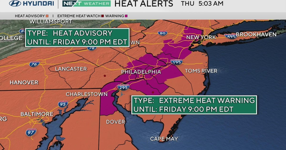
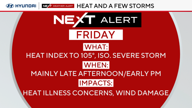
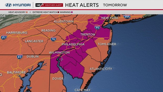
An extreme heat warning is in effect across much of the Philadelphia region on Friday, as the temperature will be pushing 100 degrees. The feels-like temperature will definitely exceed 100 in the mid-afternoon due to the high humidity over our area.
We've issued a NEXT Weather Alert for heat and strong to severe storms that could fire up on Friday evening.
A flood warning is in effect for parts of South Jersey, including Cape May, until 12:45 a.m. Saturday.
A severe thunderstorm watch was in effect for Philadelphia and surrounding counties, along with parts of South Jersey and Delaware, until 9 p.m.
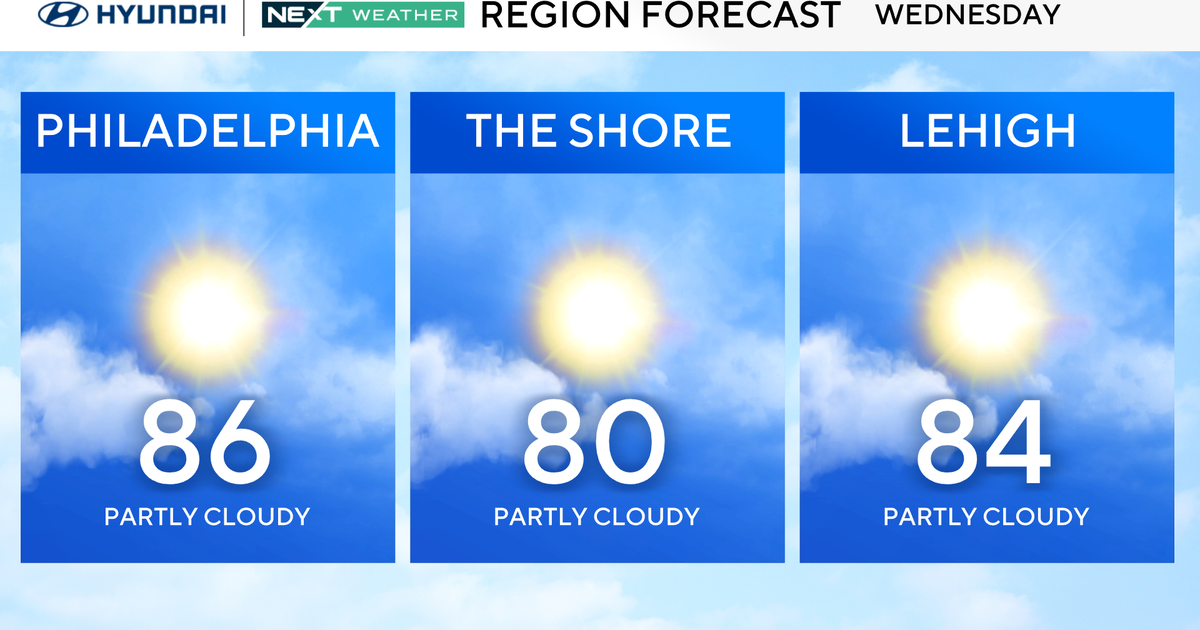
Dewpoint temps will be going back into the mid-70s, so get ready to sweat when heading outside. In addition, your air conditioner will likely be cranking back on, no more comfortable nights with the windows open. July will be ending on an unseasonably hot note (after a few relatively cool days).
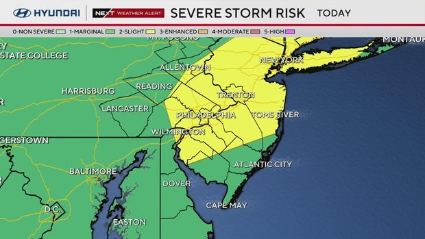
At this point, the Storm Prediction Center has our region in a marginal risk for severe storms (1 of 5). However, there are parts of the area, mainly north of Philly, that are in the level 2 risk, including Montgomery, Bucks and Mercer counties.
Extreme heat warning in effect in 11 counties around Philadelphia area
An extreme heat warning was in effect from 10 a.m. to 9 p.m. Friday for these counties or portions of counties:
- New Castle County
- Delaware County
- Philadelphia County
- Lower Montgomery County
- Lower Bucks County
- Salem County
- Cumberland County
- Gloucester County
- Camden County
- Northern Burlington County
- Mercer County
Other counties in our region were under a heat advisory from Friday morning until 9 p.m.
More storm chances this weekend; another heat wave next week?
Saturday isn't all that bad - it's quite humid but with more clouds, it won't be as hot and just a pop up shower or storm is possible. Sunday looks pretty active though, with one band of showers in the early morning hours and then more chances throughout the day.
Another heat wave looks likely next week, with temps jumping back to the mid-90s by Tuesday.
Here's your 7-day forecast:
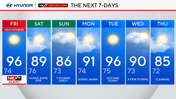
Friday: NEXT Weather Alert for heat and storms. High 96, Low 74.
Saturday: Humid, some sun. High 89, Low 76.
Sunday: Thunderstorms likely. High 86, Low 73.
Monday: Sunny, warm. High 91, Low 74.
Tuesday: Hot and sunny. High 96, Low 75.
Wednesday: A few storms. High 90, Low 73.
Thursday: Clearing. High 85, Low 72.