Heat advisory in place today for the Pittsburgh area

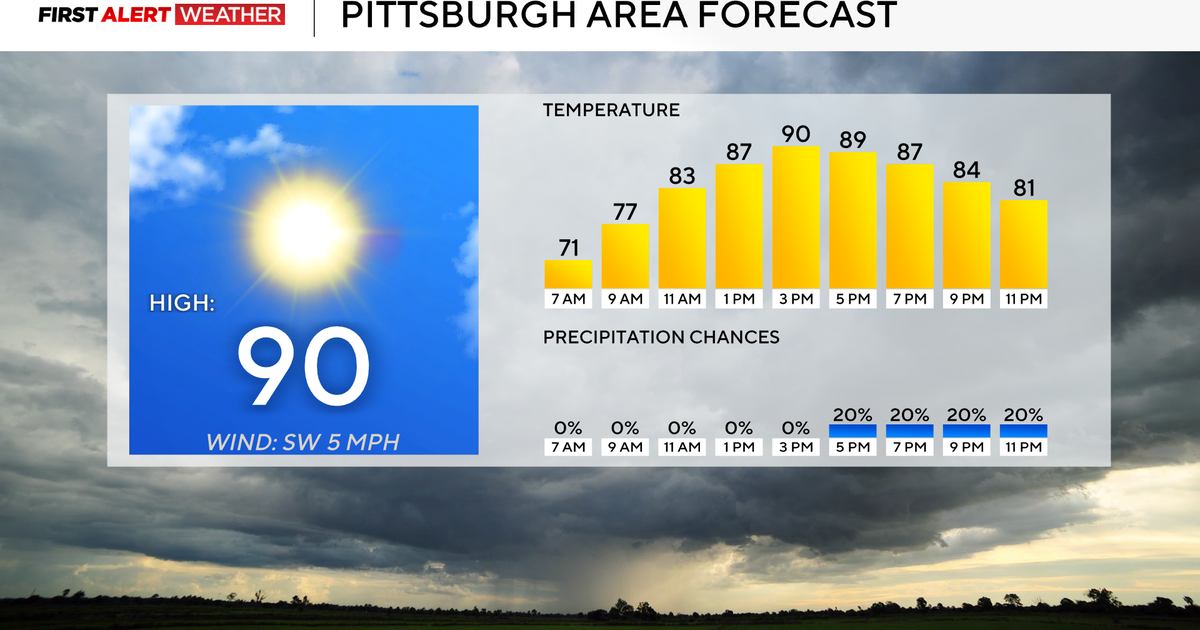
A heat advisory in place today for the Pittsburgh area with temperatures expected to reach the 90s with heat indexes in the 100s.
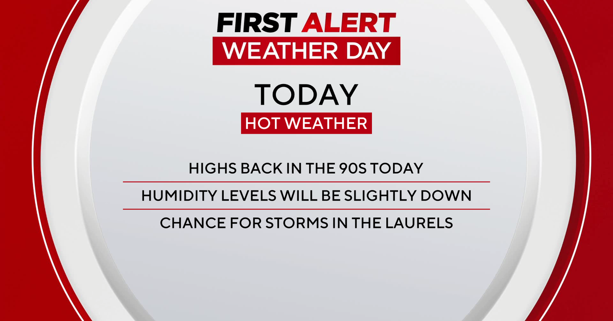
Any Alert Days Ahead? Due to the Heat Advisory issued by the NWS we have made today a First Alert Weather Day. Could potentially have another one in place Wednesday.
Aware: From June 1 through July 27th, we have spent the 4th most time on record with temperatures at or above 75°. This has been a hot summer.
No matter how you look at it, this summer has been a hot one. Data continues to show what we already know. The one I pulled yesterday was just how long we have seen temperatures at or above 75 degrees so far this 'summer'. For the stats, I pulled data from June 1 through this past Sunday, July 27th. Data shows that we stand at number 4 on the list of 'hottest' based on this, with a total of 658 hours spent at or above 75°. Last year, over the same span, we spent 706 total hours at or above 75°. For people who don't have a/c units, 75° is a good cutoff when it comes to the body's ability to cool down and recover from hot weather. It is also a good way of looking at how humid it has been over long stretches, with warmer temperatures happening when humidity levels are higher.
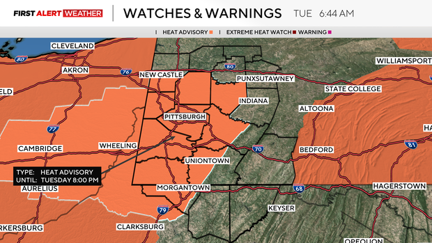
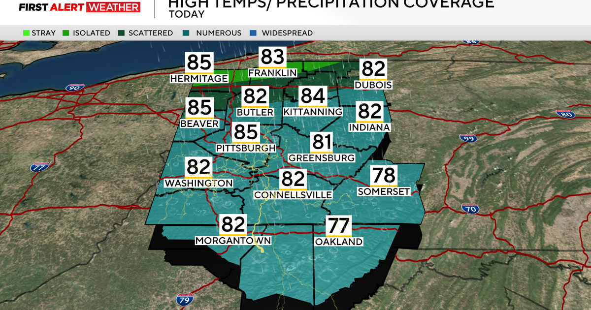
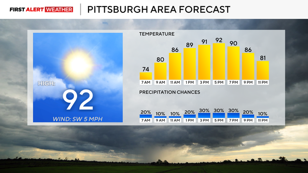
Highs today should hit the low 90s. There is a heat advisory in place for Pittsburgh and surrounding areas through 8 this evening. Heat index values should hit triple digits. A heat advisory is issued for our area when the heat index value is expected to be between 100° - 105°. That's the case for today. We may also have a heat advisory issued on Wednesday with a set-up similar to today. I have Wednesday's high temperature also hitting the low 90s with high humidity levels. Interestingly, NOAA's Storm Prediction Center has us in a marginal risk for storms on Wednesday.
Relief from the heat comes on Thursday with a cool front passing us by. Most of Thursday will still be humid, but I have highs not hitting the 80s. That to me may change. I am actually surprised that data shows us just in the 70s for the day. I have almost bumped up temperatures already, but will wait another day before bumping those highs up. To me, we should still have a hot airmass in places through at least noon. We will see more cloud cover, but it shouldn't take much to see highs in the 80s ahead of afternoon rain. Rain and storms will be strong and maybe severe as the cold front sweeps through.
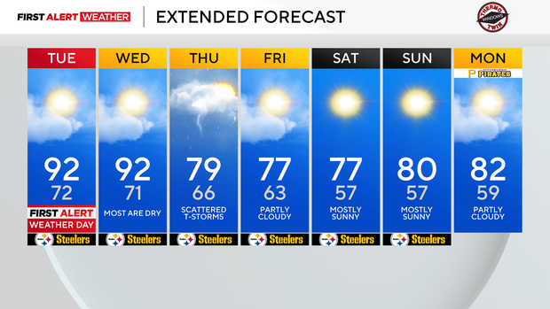
Behind the front, we will see more comfy air in place with highs in the upper 70s both Friday and Saturday. Low humidity values will make it comfy through at least next Tuesday.
WEATHER LINKS:
Current Conditions | School Closings & Delays | Submit Your Weather Photos