Northern California's mild July continues. When will the triple-digit heat return?

This July has been too good to be true. Northern California has been one of the coolest spots in the country with fall-like temperatures in what's typically our hottest time of the year.
Since mid-July, there hasn't been a hint of a major heatwave. Daytime highs across the Sacramento Valley have hovered consistently in the 80s, and just this Tuesday, many spots didn't even reach the upper 80s, a rarity for a typical summer.
So when will the heat return, and could we be looking at late summer? It's possible.
What's behind the mild pattern
The driver for our mild weather lately has been a consistent weather pattern.
Northern California has been sandwiched between two areas of high pressure, one to the north in the Gulf of Alaska and one to the southeast over the Four Corners region.
This setup has created just enough space for troughs of low pressure to dip in, enhancing the coastal marine layer and fueling a strong Delta Breeze.
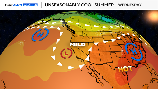
This Delta Breeze acts like nature's air conditioner, a steady, onshore flow of cool air that not only brings relief in the mornings and evenings, but has been strong enough lately to keep even our afternoons mild. Keeping us out of any summertime heat.
Patterns like this are stubborn, and current trends suggest it may hold through early August. So if you've been enjoying this cool-down, there's a good chance it will stick around a bit longer.
How does this July compare to the last?
Typically, July is one of the hottest months of the year in Northern California, often bringing multiple heatwaves and triple-digit temperatures across the Valley. But this year? Not the same.
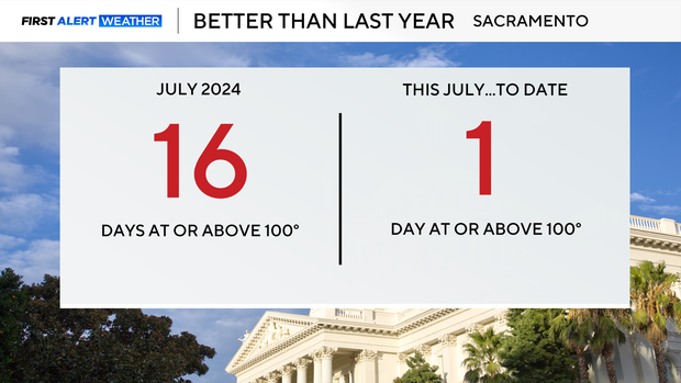
In 2024, Sacramento saw 16 days of highs at or above 100 degrees in July alone. Meanwhile, this July has so far brought only one day of 100-degree temperatures to Sacramento, on July 11.
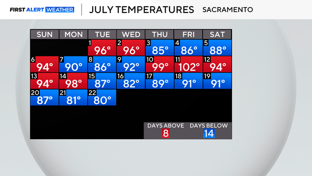
During July, Sacramento averages a high of 93 degrees. Looking at this July, we've only seen eight days at or above that number, with more than half the month below average.
Historically, Sacramento's hottest stretch of the year runs from July 9 through August 5, when average highs peak at 93 degrees. So yes, we're technically in our summer prime, but it certainly hasn't felt like it.
If we keep our stretch of mild highs through the end of the month with no other triple digits, we could tie a three-decade record.
As the last time Sacramento saw only one 100° day in July was back in 1993.
Cooler weather holds, with thunderstorms for the Sierra
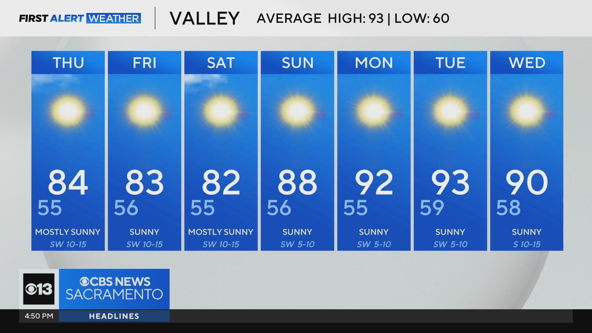
Expect highs in the low 80s to continue across the Valley through the rest of the week and into the weekend. In the Sierra and foothills, temperatures will stay comfortably in the 70s and 80s over the next seven days.
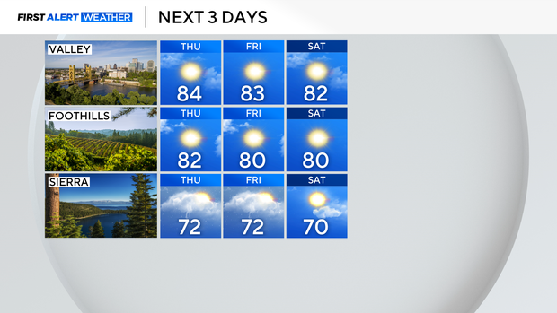
Starting Wednesday afternoon through Saturday, daily thunderstorms are likely across the Sierra thanks to growing atmospheric instability. The best chances will be along the Sierra crest and eastern slopes.
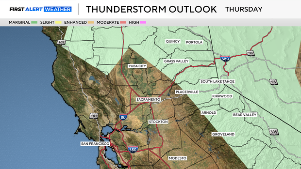
With best chances along the Sierra crest and eastern slopes. These storms will not be big rain-producers, yet storm threats will mainly be dry lightning, small hail, gusty winds and brief heavy rain. The dry lightning risk will keep fire danger elevated through the weekend.
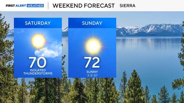
If you have any outdoor plans in the mountains, Sunday looks to be the best day with fewer storms expected.
Temperatures begin to climb again toward the end of the month, with highs returning to the low and mid-90s by July 28–29.
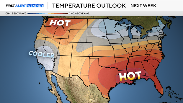
But even as we warm up, the overall pattern through the end of July and early August keeps California among the coolest regions in the country. According to the latest outlook from the Climate Prediction Center, below-average temperatures are likely to continue over the next 6–10 days.
Make sure to stay with the CBS Sacramento First Alert weather team for updates to our mild summer pattern.