Alert Days in effect as temperatures soar this week

Hot weather is here!
BWI-Marshall peaked at 90° on Saturday afternoon and has managed to warm even further Sunday afternoon, despite more clouds.
The First Alert Forecast dries back out through mid-evening. Temperatures continue to gradually cool Sunday night, into early Monday morning. Plan on a dry and mostly sunny start to Monday. Temperatures will be in the mid to upper 70s across much of the Baltimore metro at 6 a.m. A few spots closer to the bay may only briefly dip to 80° .
Temperatures soar into the 90s by noon, Monday.
WJZ Alert Days in place across Maryland for extreme heat
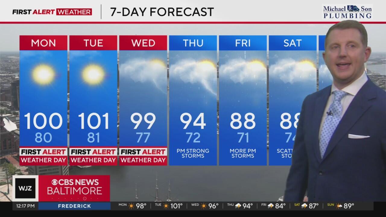
The combination of near triple digit heat and elevated humidity levels have prompted the WJZ First Alert Weather team to issue Alert Days through Wednesday of this week. Maximum temperatures will peak close to 100° each of those days. Monday and Tuesday the most likely afternoons to surpass that mark. This could rival high temperature records at BWI.
Heat is the number one weather-related cause of death in the United States. Please take the Alert Days seriously, especially if you will be outdoors in the next couple of days.
With hotter temperatures on the way, additional heat alerts will be active across much of Maryland:
- A heat advisory will go into effect for for much of the Eastern Shore starting 8 am on Monday through 8 pm Tuesday evening.
- An extreme heat warning for central Maryland will go into effect at 11 am Monday morning through 9 pm Monday evening. Feels like temperatures could approach 110° for these areas.
Regardless of whether or not your neighborhood is in an alert, the entire area will be extremely hot and humid.
A few ways to stay safe and healthy while working outside during extreme heat -
- Wear loose fitting, light colored clothing
- Take frequent breaks if you plan to be outdoors
- Drink lots of water, even if you don't feel thirsty
- Remember pets and the elderly in the heat
In preparation for the unusually hot weather, Baltimore City's Health Department is declaring its first 'Code Red Extreme' Heat Alert. The alert begins Sunday and runs through the middle of the week. A list of available cooling centers is listed on the city's website.
Temperatures trend slightly cooler late this week
Temperatures eventually begin to slowly ease away from the century mark late in the upcoming week. This will also come with increased shower and storm chances thanks to a front expected to inch closer to the Maryland-Pennsylvania state line from the north. We're still forecasting highs in the low 90s Friday into the final weekend of June. Humidity is forecast to remain elevated.


