Severe weather expected to return to Maryland Wednesday


After a more subdued weather day across Maryland on Tuesday, storm chances are set to return midweek, bringing the potential for heavy rain and isolated flash flooding.
A Tornado Warning has been issued for Carroll County and Baltimore County until 9 p.m.
Only a few storms developed Tuesday afternoon, mainly in southern Maryland and on the Eastern Shore. Skies will turn partly cloudy overnight with patchy fog possible. It will remain humid, with lows in the mid-70s.
Flood risk, severe weather on Wednesday
A more active pattern resumes Wednesday as scattered thunderstorms are expected to develop during the afternoon.
With high temperatures near 90 degrees and elevated humidity, some storms could become strong, producing very heavy rainfall. Isolated flash flooding is possible where storms stall or repeatedly move over the same areas.
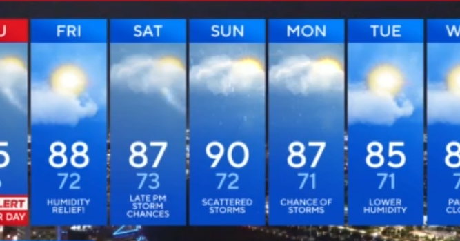
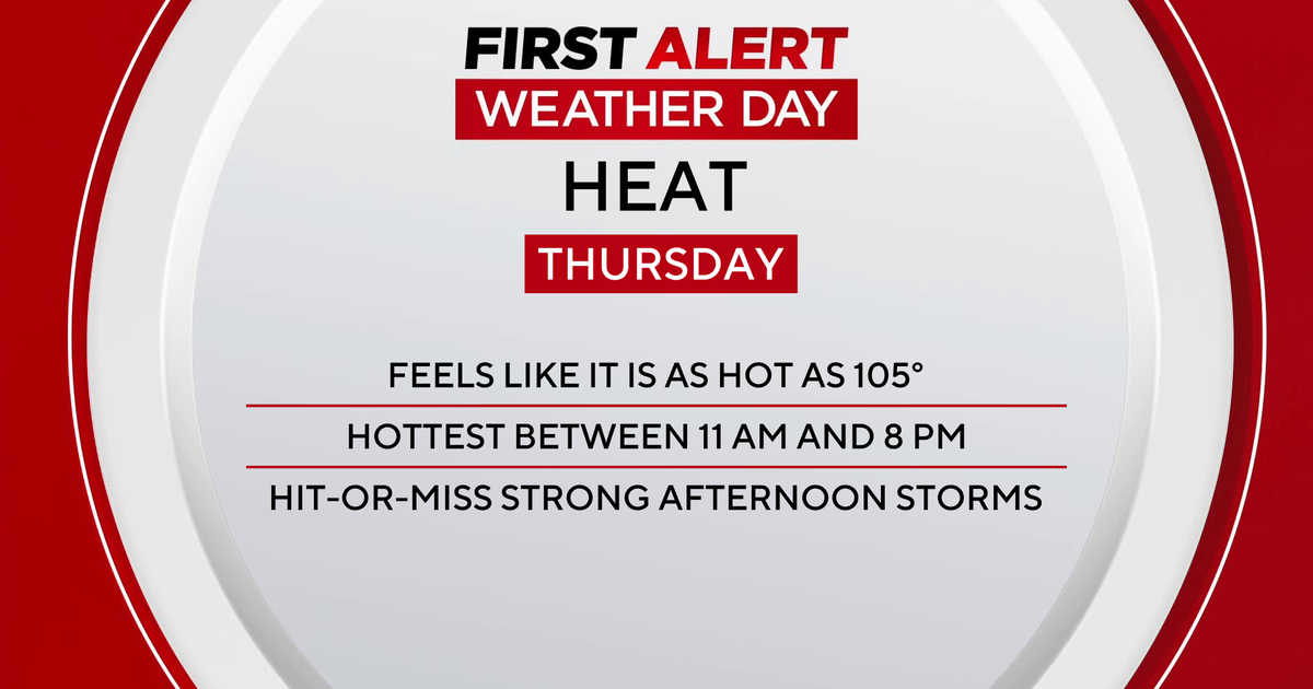
Thursday will bring drier conditions overall, but heat remains a concern. High temperatures will climb into the low to mid-90s, and heat index values may exceed 100 degrees. A stray afternoon or evening storm can't be ruled out.
Chance for severe weather Friday
Friday brings renewed storm chances. Afternoon highs will reach around 90 degrees, and increasing instability could trigger stronger storms. Locally heavy rainfall may lead to flooding. Depending on how the threat develops, a WJZ First Alert Weather Day could be issued.
dry start, wet finish to the weekend
Saturday is shaping up to be the driest day of the weekend, with a frontal boundary pushing south of the area during the morning. Most storms that do form will likely stay across Virginia and southern Maryland.
By Sunday, the front will lift back north, increasing storm coverage again. Scattered to numerous storms are expected by Sunday afternoon and evening, with highs in the upper 80s.
Unsettled weather pattern continues next week
The same front is forecast to stall across the region early next week, keeping conditions unsettled. Scattered to widespread thunderstorms are possible each day through at least Tuesday. The timing and intensity of storms will depend on where the front settles and the arrival of upper-level disturbances.
While storm chances remain high, there is a bit of good news: Temperatures may ease slightly by the middle of next week. Highs in the low to mid-80s are expected to become more common, offering some relief from the persistent heat and humidity.