Dangerous Maryland heat wave continues through Wednesday
 By
,
By
,

Dangerous levels of heat and humidity will continue across Maryland overnight and into Wednesday with highs close to 100°. Record highs may be tied or broken across the state through Wednesday. Heat index values will continue to be extreme and overnight lows near 80° will offer no relief.
Everyone is advised to take heat precautions seriously, as the temperatures will be dangerous even to healthy individuals.
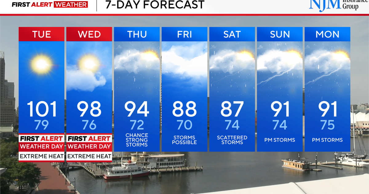
Baltimore has declared a Code Red extreme heat alert through Thursday, June 26.
Extreme heat and humidity continue across Maryland
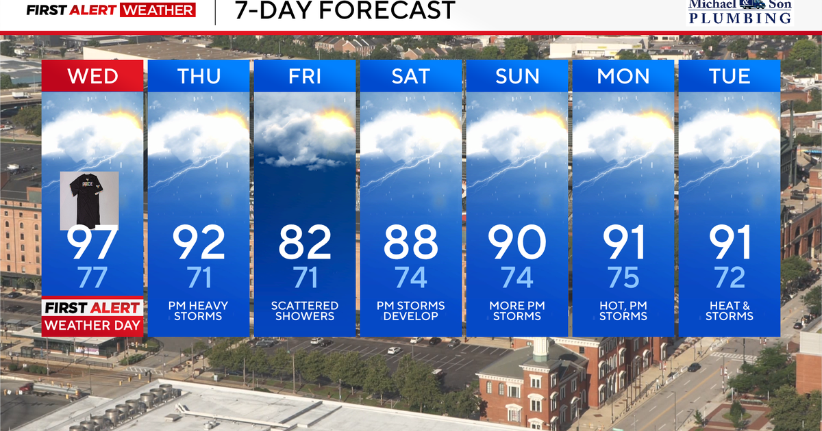
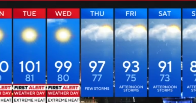
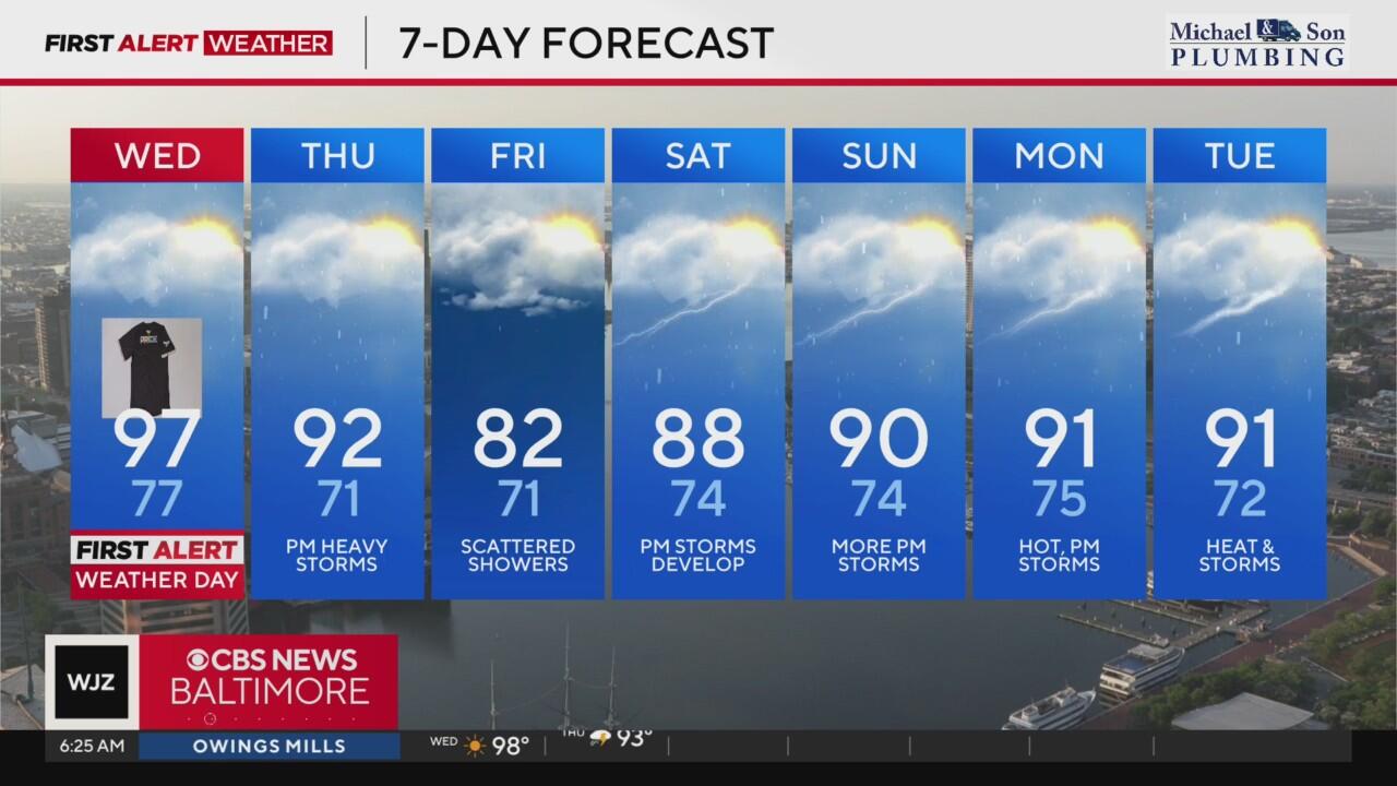
The combination of near triple-digit heat and elevated humidity levels has prompted the WJZ First Alert Weather team to issue another Alert Day for Wednesday, June 25. We'll once again be monitoring near-record heat. Our normal high temperatures for late June are in the upper 80s.
BWI reached 98° Tuesday afternoon, two degrees shy of the 2010 record.
Meanwhile, the Inner Harbor surpassed the century mark for another day, peaking at 105° Tuesday.
Wednesday will also feature dangerous heat, but high temperatures should fall just shy of 100°. BWI's record high for June 25th is 99° from 1997 and right now our forecast calls for us to be a degree or two short of that record. The warmest low temperature on record for that same date is 78°, set in 1875. Records for the Baltimore area go back to 1872.
Regardless of whether we see new records on Wednesday, prepare for more highly uncomfortable levels of heat and humidity statewide. Feels like temperatures will be between 100° and as high as 110° for most. While this will be a couple of degrees lower than days past, it'll still be dangerous if you don't prepare.
Isolated strong and possibly drenching thunderstorms are possible Wednesday afternoon and evening, and another, possibly higher, chance of storms comes on Thursday.
Heat alerts in Maryland
Heat is the number one weather-related cause of death in the United States. Please take the Alert Days seriously, especially if you will be outdoors now through Wednesday evening.
As the extreme heat continues, additional heat alerts will be active across much of Maryland:
- The Eastern Shore is under an extreme heat warning through Wednesday at 8 p.m.
- Extreme Heat Warnings continue for central Maryland through 9 p.m. Tuesday. Feels like temperatures could approach 110° for these areas.
- A heat advisory is in effect for central Maryland starting at 11 a.m. Wednesday through 9 p.m.. Feels like temperatures could approach 110° for these areas.
Regardless of whether or not your neighborhood is under an alert, the entire area will be extremely hot and humid, even overnight. Low temperatures in the 70s and 80s are warm enough, but with high levels of moisture, we'll wake up already feeling like the mid-80s again on Wednesday.
Beating the heat during this Maryland heat wave
Here are a few ways to stay safe and healthy while working outside during extreme heat:
- Wear loose-fitting, light colored clothing
- Avoid being in the direct rays of the sun
- Take frequent breaks if you plan to be outdoors
- Drink lots of water, even if you don't feel thirsty. Two liters of water a day is recommended
- Remember pets and the elderly in the heat
- Make sure ceiling fans are circulating counterclockwise to circulate cooler air downward
In preparation for the unusually hot weather, Baltimore City's Health Department is declaring its first 'Code Red Extreme' Heat Alert. The alert begins Sunday and runs through the middle of the week.
Late week storms then brief relief Friday
Thursday should be the last day of this current heat wave. While extreme heat warnings are not likely Thursday, we're still forecasting hot and steamy temperatures. Highs Thursday afternoon will reach the lower 90s with heat index values close to 100°.
A cold front will continue to sag south Thursday afternoon sparking off numerous showers and thunderstorms. A few of these storms could be strong to severe with locally damaging winds. The greater risk from these storms may be localized flash flooding given the high humidity values and potentially slow-moving storm motions. Some neighborhoods could receive locally a quick 1 to 3 inches of rain while other neighborhoods will receive far less from these hit or miss storms.
Friday will be much cooler as the cold front sinks south of us. High temperatures may not even reach 80° in some neighborhoods. There is the chance of showers Friday, especially during the morning.
Steamy summer weekend across Maryland with more storms
The upcoming weekend will turn hotter and more muggy once again as the cold front that brought relief Friday lifts north as a warm front.
Expect variable clouds with hot and muggy weather Saturday and Sunday. Widely scattered to scattered thunderstorms will develop during the afternoon and evening hours. These storms will be of the hit or miss variety, so not every neighborhood will get wet. Neighborhoods that do receive storms could receive locally heavy rainfall, cloud to ground lightning, and gusty winds.
Highs over the weekend will be steamy. Saturday's highs will climb toward the upper 80s. Sunday's high temperatures will reach 90°, but with high humidity levels, feels like temperatures will top out in the middle to upper 90s.